ODIS Overview
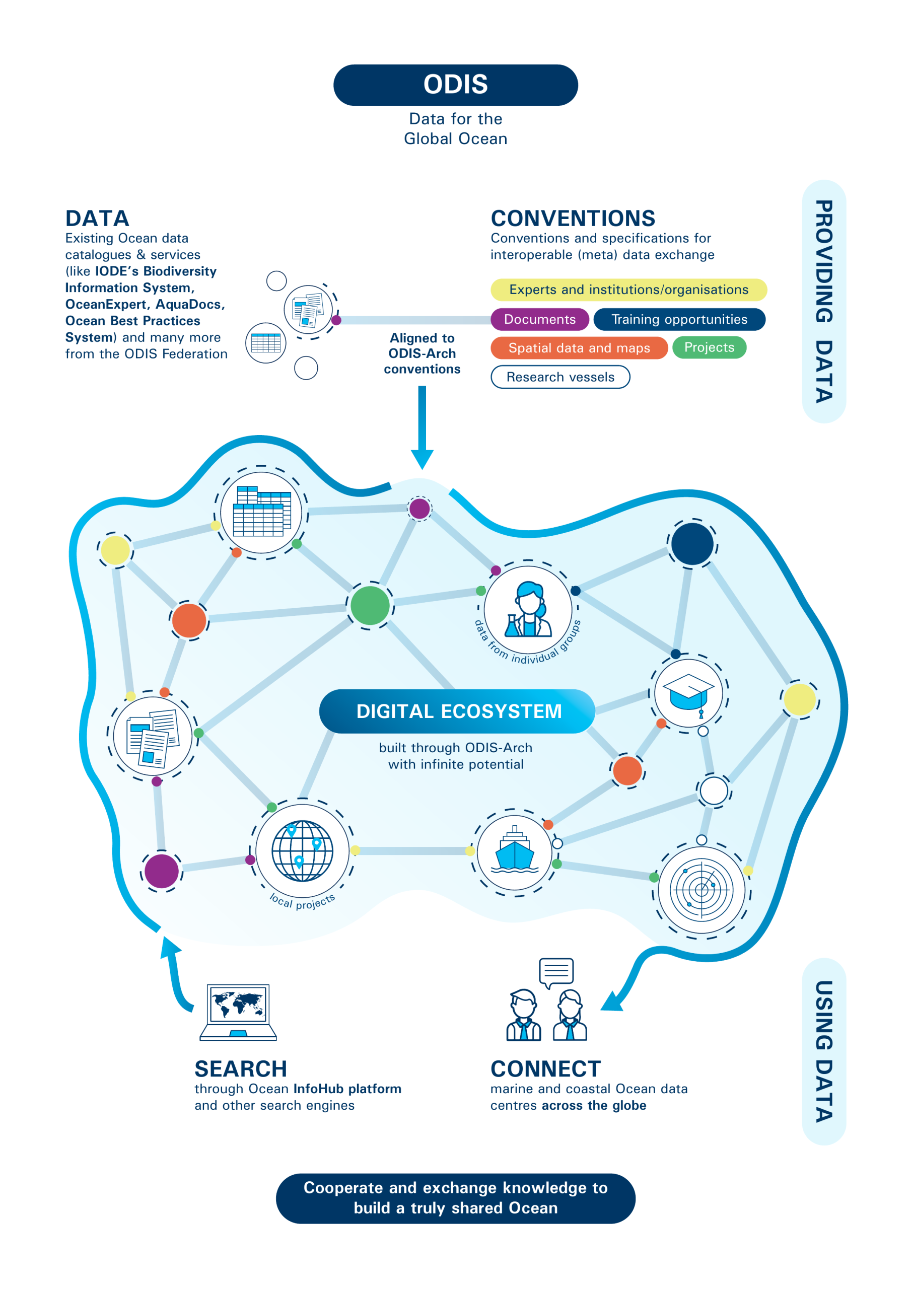
The Ocean Data Information System (ODIS) is a federation of systems that uses common conventions to share and exchange their (meta)data. ODIS is not a new portal or centralised system under the control of a single authority, but a partnership of distributed, independent systems voluntarily sharing (meta)data and information along co-developed and clear conventions in the pursuit of common goals. These conventions have been formalised and operationalised in the ODIS Architecture to allow existing and emerging ocean data and information systems, from any stakeholder, to interoperate with one another. This enables and accelerates more effective development and dissemination of digital technology and sharing of ocean data, information, and knowledge for sustainable development.
The overarching goal of the Ocean Data and Information System (ODIS) in the long term, is to provide a sustainable and responsive digital ecosystem where users can discover data, data products, data services, information, information products and services provided by IOC Member States, independent projects, private sector partners, and other partners associated with the UN Decade of Ocean Science for Sustainable Development.
The ODIS Architecture (ODIS-Arch) is more than a single specification — it includes the shared conventions, technical stack, and workflows that Nodes adopt to make their (meta)data interoperable. Full technical details, including the underlying architecture and tooling, are available in ODIS architecture documentation and the Github Repository: https://github.com/iodepo/odis-arch
New to the IODE, NODCs or ADUs?
Many ODIS Nodes operate as National Oceanographic Data Centres (NODCs) or Associate Data Units (ADUs) within the IODE network. If you're unfamiliar with these roles — or are interested in establishing one — the resources below can help:
An ODIS Node is a data source that is networked into and part of the ODIS Federation, operated by ODIS partner organisations, which may have one or many Nodes; many Nodes operate as National Oceanographic Data Centres (NODCs) or Associate Data Units (ADUs) within the IODE network. ODIS harvests (meta)data from all ODIS Nodes, and builds a collective Knowledge Graph to promote global discovery and action.
The ODIS Catalogue of Sources is an online browsable and searchable catalogue of existing ocean-related web-based sources and systems of data and information, as well as products and services. Nodes contribute to this ecosystem by registering their resources in the Catalogue. It was one of the precursors to ODIS, and also provides information on products and visualization of the landscape (entities and their connections) of ocean data and information sources. The Catalogue is not an ocean database or metadata repository; it includes descriptive information such as the URL, title, description, language, point of contact, geographic scope, available technologies for machine-to-machine interaction, and keywords, and can be searched on many of these fields.
History
The foundation for ODIS was established by the Ocean InfoHub (OIH) Project in 2020. The IOC Assembly at its 31st Session (2021) formally established ODIS through Decision A-31/3.4.2., ensuring its long term support as a stand-alone project. Subsequently, IODE-XXVII decided to designate ODIS as one of three IODE Programme Components, which has further strengthened its long term support. The Ocean Data and Information System as a Programme Component of IODE continues to be sustainably supported into the future using UNESCO Regular Programme funding, and with technical support by the IODE. Extra budgetary funding continues to be actively sought to expand and develop the system further, adding functionality as requested by end users, linking partners from new regions around the world, and also to develop OceanData 2030 in support of the UN Decade of Ocean Science for Sustainable Development.